Update! The GiSTEQ PhotoTrackr now supports MAC.
On August 7th I received a fantastic product to review, the GiSTEQ PhotoTrackr. I put it through many paces in the time since and am now able to give you my findings.
The GiSTEQ PhotoTrackr is for photographers (professional and amateur), especially those who take photos and post them to Flickr and other online photo hosting sites like locr. The GiSTEQ PhotoTrackr is a hand held GPS unit that you can use to track the locations where you take your photos as well as generate a breadcrumb trail of your entire trip. You can even tag places as waypoints with the
I have taken my GiSTEQâ„¢ PhotoTrackrâ„¢ out on many photowalks to test out the reliability and accuracy of the device.
Overall findings: The GiSTEQ PhotoTrackr ROCKS! And the GPS is very accurate. I have put it on the dashboard of a car and driven across Minnesota. I’ve put it in my camera bag and shot photos all day long. I’ve walked with it in my pants pocket and shot photos all day. Each of these scenarios kept me connected to the satellites. The GiSTEQ PhotoTrackr is small and light enough for me to never even know it is with me. Just get the signal and put it wherever you’d like to store it, it continues to work during your whole trip. The only places it does not work are inside buildings.
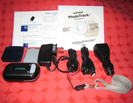
The unboxing – I received my GiSTEQ PhotoTrackr and opened the box to find.
* 1 PhotoTrackr GPS unit
* 1 Re-chargeable battery
* 1 PhotoTrackr Software CD
* 1 USB cable
* 1 Vehicle Charger for the GPS unit
* 1 Wall Charger for the GPS unit
* 1 Sticky Pad for securing the GPS unit on the vehicle
I immediately read the instructions, inserted the battery and gave it a charge. I waited 3 hours for the unit to be fully charged and then installed the GiSTEQ PhotoTrackr software. Once that was installed I synchronized my camera time to the GPS time. This is what allows the data from the GPS and your camera files to merge properly. I then took the GiSTEQ PhotoTrackr with me on a walk around the block to give it a quick test.
The first test went pretty well, I took a bunch of photos and then uploaded them and the GPS information to my computer and then I was able to see a map of the trip I took with each photo along the way.
The Software – The GiSTEQ PhotoTrackr comes with software that is fairly simple to use but it can do some powerful things. At first glance I thought it was basic but as I spent more time working with it I could see some additional functionality that was pretty impressive.
Features:
* Share your photos with family and friends with location mapping in GiSTEQ PhotoTrackr software. (With integrated Google Maps.)
* Integrated with Flickr / locr / Picasa Web Album / SmugMug for easy online photo sharing.
* Keep track of your digital photos with satellite precision.
* Display or playback trip routes with the GiSTEQ PhotoTrackr software.
* Compatible with ALL digital cameras
* Light weight & low power consumption.
* Power saving with build-in vibration sensor.
* Automated photo slideshow function.
* Geo-tagged function enables image-sharing in 3rd party Geo-photo sharing websites.
* Capable of writing GPS info to the pictures and exporting NMEA and GPX info from the GPS log files
* Google Earth support (GiSTEQ PhotoTrackr program is able to export GPS log files and pictures to Google earth format)
* Multi-language support (GiSTEQâ„¢ PhotoTrackrâ„¢ software now supports Chinese, English, French, German, Japanese, and Spanish.)
I’ve spent enough time working with the GiSTEQ PhotoTrackr to have used many those features and they are really impressive. The way I use my GiSTEQ PhotoTrackr is simple.
I charge it up before a trip. I don’t really have to because the battery holds a very long charge and uses very little power. However, I am obsessive and fear running out of power on all my gadgets. I get to my location and turn on the PhotoTrackr before I do any shooting. When the GiSTEQ PhotoTrackr is turned on a voice tells me “Satellites Positioning” and I know that it is looking for the satellites. Then I get the announcement that we have “Satellites fixed!” Now I am good to go.
![]() I shoot with two cameras. I have a Nikon D80 DSLR and a Canon SD800is. I have also gone on photowalks with other people using the Nikon D40 DSLR and a Canon SD600. And each one of these cameras work perfectly with the PhotoTrackr. All I need to do is sync their camera clocks with the GPS Satellite Clock. So each and every person on the photowalk can use the same GiSTEQ PhotoTrackr to GPS tag their images.
I shoot with two cameras. I have a Nikon D80 DSLR and a Canon SD800is. I have also gone on photowalks with other people using the Nikon D40 DSLR and a Canon SD600. And each one of these cameras work perfectly with the PhotoTrackr. All I need to do is sync their camera clocks with the GPS Satellite Clock. So each and every person on the photowalk can use the same GiSTEQ PhotoTrackr to GPS tag their images.
![]() If you are photowalking with a large group you can add multiple users to the GiSTEQâ„¢ PhotoTrackrâ„¢ software. Each photographer can have their own profile. You can sync their cameras and you can keep track of their names and addresses. So if you are building a photowalking community in your area you can keep track of user information to contact everyone for the next event. That software can also be used if there are multiple people using multiple GiSTEQ PhotoTrackr devices. You can use the GiSTEQ PhotoTrackr to track drivers as well so not just for photography.
If you are photowalking with a large group you can add multiple users to the GiSTEQâ„¢ PhotoTrackrâ„¢ software. Each photographer can have their own profile. You can sync their cameras and you can keep track of their names and addresses. So if you are building a photowalking community in your area you can keep track of user information to contact everyone for the next event. That software can also be used if there are multiple people using multiple GiSTEQ PhotoTrackr devices. You can use the GiSTEQ PhotoTrackr to track drivers as well so not just for photography.
When I get home I first edit my photos in Adobe PhotoShop Elements. The GiSTEQ PhotoTrackr Software is not a photo editing software solution, nor does it claim to be. I use Elements to crop, sharpen and color correct my photos. When I am done editing I make sure that I use the “save as” option to save my images. I do this because it retains the EXIF data from the original image. EXIF data is a factor in making geotagging possible.
![]() I then open the GiSTEQ PhotoTrackr software. I attach my GiSTEQ PhotoTrackr to my computer via USB cord and I am asked to download my GPS information. Once it is in I can name the trip. Tip: While you are out taking photos take care not to turn off the GiSTEQ PhotoTrackr. When that happens and you turn it back on you get a second GPS file. That means that when you look at your trip in the software it is split in two trips. The system asks whether you want to delete the trip records or not. Delete them, that way on your next trip you start fresh.
I then open the GiSTEQ PhotoTrackr software. I attach my GiSTEQ PhotoTrackr to my computer via USB cord and I am asked to download my GPS information. Once it is in I can name the trip. Tip: While you are out taking photos take care not to turn off the GiSTEQ PhotoTrackr. When that happens and you turn it back on you get a second GPS file. That means that when you look at your trip in the software it is split in two trips. The system asks whether you want to delete the trip records or not. Delete them, that way on your next trip you start fresh.
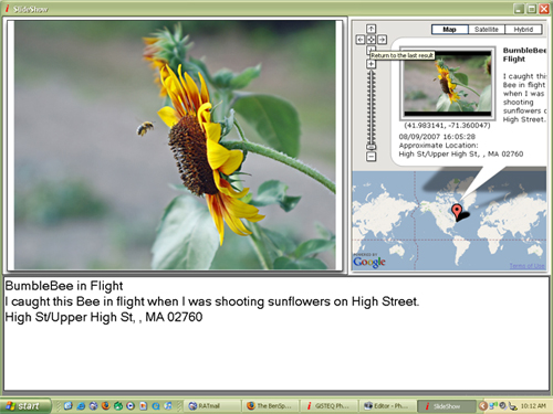
![]() Once the trip is uploaded I then move to photo management. I click the Add Images button and grab those images that I recently edited. The software will ask if I want to copy the images to the computer. Make sure you do this because if you leave them on your memory card and you come back to work on the software and your memory card is not in the computer you will get an error message that the images cannot be found. The GiSTEQ PhotoTrackr software isn’t just a weigh station, it can be used to showcase your trips via a slide show. Without the images on the computer you won’t be able to show these slide shows unless the memory card is inserted in the computer. The slide show shows the image as well as where the image was taken on the map. There is also an area that you can use to edit the image’s title and a description. Here is an example of one of my images in slide show mode.
Once the trip is uploaded I then move to photo management. I click the Add Images button and grab those images that I recently edited. The software will ask if I want to copy the images to the computer. Make sure you do this because if you leave them on your memory card and you come back to work on the software and your memory card is not in the computer you will get an error message that the images cannot be found. The GiSTEQ PhotoTrackr software isn’t just a weigh station, it can be used to showcase your trips via a slide show. Without the images on the computer you won’t be able to show these slide shows unless the memory card is inserted in the computer. The slide show shows the image as well as where the image was taken on the map. There is also an area that you can use to edit the image’s title and a description. Here is an example of one of my images in slide show mode.
The main GiSTEQ PhotoTrackr software work area is packed with information as well as many things to do. Click the image for a full look at my current workspace. I would also like to point out that the different windows in the workspace can be expanded or contracted so that you can see more of one area and less of another.
I’ll now take you through the GiSTEQ PhotoTrackr workspace.
 |
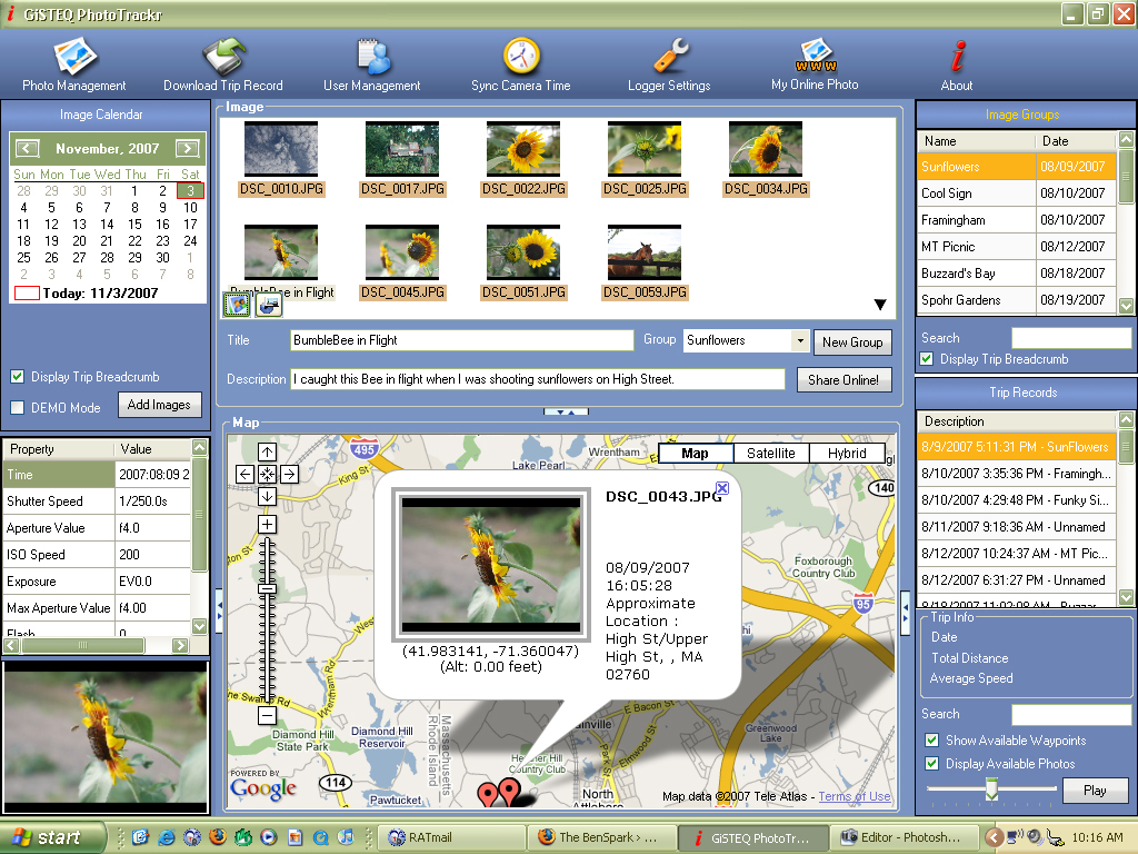
The Image Calendar: This part of the workspace is important because you can easily see what days you used the GiSTEQ PhotoTrackr. When you click on a day you see the images from that day as well as the map. You also use this area to add additional images. |
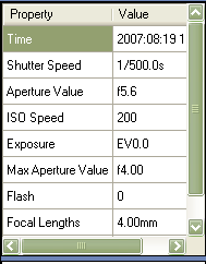 |
The Properties Window: This area shows the EXIF data for the image selected. Information like shutter speed, time the image was taken and ISO speed are just a few of the bits of info that you can see. |
 |
|
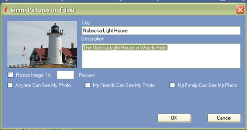
| The Image Window: This part of the workspace is full of things to do. First off you can click on any image in the image window and the map below will shift to show where that image was taken. There are two icons in the bottom left of the image window. One is for the slide show and the other is to export the trip to Google Earth. This is also the area where you can name each image and write a description. Do this before you attempt to upload your images to Flickr or locr. Here you add the image title, set it to a particular image group or even generate a new image group. Once you define this information for your image you can click the share online button. A new window will open. | |
 |
|
| With this window you can determine if you want to reduce the image size. This is not necessary if you edit your images before you import them into the GiSTEQ PhotoTrackr software. You can also set the privacy filters for your images. Images can be set to be seen by anyone, by family or by friends.
If you have named each of your images and added titles to each of them already you can select all images and upload them all in one shot. |
|
 |
|
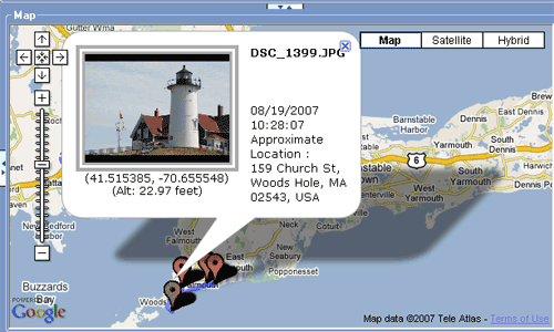
| The Map Area shows your trip in a Google map. When you click on an image in the image window it will show up below on the map and the map will shift to show that image. On the map itself you can click on the push pins and see what image appears. Also you can follow the trip with the highlighted breadcrumb. You can also click the play button at the bottom right of the workspace under the Trip Records Section (see below). This will start a green dot moving along the trip track. When you come to an image it will pop up and show you that image. | |
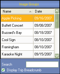 |
The Image Groups Section is where you can search or sort through each of your individual groups of images. You can sort the list by name or by date. In addition you can use the search box to find a particular image group. When you find the image group that you are looking for you can click on it and the images will come up in the images window and the map will appear in the map window. You can also decide to turn the breadcrumb of the trip on or off. |
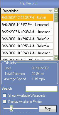 |
The Trip Record area lists out each individual trip. You have the option to name your trips. As a default the trips are shown by date then time and set to unnamed. You can edit the name or you can edit the entire thing. I like to edit the unnamed part so that the trip record and the image group has the same name. There is also a search feature here as well. When you click on a trip record you can see the date of the trip, the total distance as well as the average speed. It is one of the fun information tidbits that I enjoy knowing. You can easily tag a location as a waypoint as well. You can do this by pressing the left button on the GiSTEQ PhotoTrackr while you are out shooting. I have not done this yet. I am going to try that soon, too.
In the Trip Record Area you can set your trips to ‘play’. A little green dot goes from location to location on the map. It follows the trip breadcrumb. |
So those are the features of the GiSTEQ PhotoTrackr device and software. I have started a few groups to help as resources for other users of the GiSTEQ PhotoTrackr. You can go there to see photos that have been geotagged by the GiSTEQ PhotoTrackr as well as learn more about the product.
Here are the groups.
- GiSTEQ PhotoTrackr Flickr Group
- GiSTEQ PhotoTrackr Zooomr Group
- GiSTEQ PhotoTrackr Blog Catalog Group
- GiSTEQ PhotoTrackr Facebook Group
GiSTEQ has their own forum for user support as well.
Here are some of my photowalks while using the GiSTEQ PhotoTrackr.
- Falmouth Photowalk
- Falmouth PhotoBlading
- Shelburne Farms Photowalk
- Topsfield Fair Photowalk
- Las Vegas PhotoWalk
Here are my photos that are tagged with the words GiSTEQ PhotoTrackr
I also added my photowalks to Zooomr. The thing about the GiSTEQ PhotoTrackr and Zooomr is that once you add the GPS data to your images and upload them to Zooomr they are automatically geotagged. Support for Zooomr is not officially specified but it is something that works.
Follow these steps..
1. – Edit your images
2. – Import your images into the GiSTEQ PhotoTrackr Software and add GPS data.
3. – Upload your images to Zooomr.
Here are my two Zooomr smartsets.
Falmouth Photowalk
Falmouth PhotoBlading
In addition to the standard version of the GiSTEQ PhotoTrackr there is also a BlueTooth version and an upgraded software version, GiSTEQ PhotoTrackr Pro, that supports Raw formats.
You can buy the GiSTEQ PhotoTrackr on Amazon.com
A lot easier way to this that involves NOTHING in the way of s/w, etc. is to buy a $100 GPS unit (that is useful for many things) and simply take a picture of its screen where you are taking pictures.
Not really Scott. That would just show the relative area and you would have to do more work to get the GPS data added to your image. In your scenario I would take a picture, then take a picture of the screen of my GPS. Go to another location do the same thing. Seems like a waste of time when you can have the PhotoTrackr keep track of the locations for you. Sounds like you are making more work for yourself to save a couple bucks. No thanks, my time is worth the expense of a product dedicated to photo tracking.
Hi Drew,
This is very interesting! Does the GPS unit also give you directions about where to go (i.e. to go to Starbucks, turn right in 50m, then turn left after 100m), or is it just a GPS data logger?
My company is thinking of selling a similar product (we just heard about it from a supplier of our’s), but since I don’t have any experience with it, this post was really helpful! I have manually geotagged some personal photos (a big pain after tagging only a few photos!) so the product definitely holds interest for me.
If we did decide to carry a similar but different branded product, what is your policy on submitting one to you for review?
Thanks!
p.s. Found your blog through your Photojojo forum post.
Hi Berta,
The PhotoTrackr is a GPS data logger, there is no display. The real magic is in the software. There was even a new release to the software that happened today that gives it even more features. After Blog World Expo I will be posting about those features.
As far as submitting a product to me to review. The best way to contact me is via my e-mail and you should have it with this response. Go ahead and e-mail me about it and we can talk about how to deliver the product to me as well as what sorts of things you are looking for me to highlight and test. I will run my own tests as well. I look forward to hearing from you. And thanks for stopping by through PhotoJojo.
I live in Australia and purchased PhotoTrackr from the States mid year. I trialled this unit locally and it did what it claimed. In September I had holidays, Thailand as two stopovers and three weeks in Italy. The Gisteq unit did not require charging during the entire trip. It was turned off when not taking photos for a couple of hours or more. The software matched the GPS to my downloaded photos ( approx. 1700 images ) with an accuracy that is outstanding. I was totally blown away by the performance of this tiny unit, and can highly recommend it.
ok, so once you’ve geocoded your pics how can u publish them to the web? Imthinking more on the lines of MySpace and not the cutom made websites?
there seems to be very little tools that enbale the use of embedded google maps to show your geotageed videos and photos and tracks e.g from an uploaded gpx file.
Ive looked long and hard on the web and there is nothing allows you to do the obvious with geotagged media unless u just wanna create your own KML file and launch it on your desktop!
John,
That is excellent. Do you have a flickr account or Zooomr. I would love to see those photos sometime. If you are on Flickr send me a note to get added to the GiSTEQ PhotoTrackrs group.
Hi Sting, Funny that you should ask that. While I don’t know about things like myspace, it isn’t really a place for geotagging like Flickr and Zooomr and locr are. However if you want to put a mp on your blog that s something that has been added as an enhancement to the software in the latest release update.
This thing looks sweet. A friend of mine wrote his own photo album using the Google Maps API long before it was available on the free sites to use this data. It makes it easy to browse photos geographically. I wrote an article on it back in April here http://thoughtsfrommylife.com/article-218-Adding_Google_Maps_to_Your_Photo_Album
This device would add the other component he was missing since he hand typed in his own coordinates.
hi dose the software work for mac computers .photo links ,said they would at the javets ccenter, but like jobo cant comunikate with them .im new to coms.
hi this popted back up ,dose the gps software work on macs .thankyou.
Hi chris,
The software is PC based. No Mac that I know of.
Hi, thanks for the amazing review! I intend to buy one and have a couple of questions:
1) Does the software improvise? Like when I take a picture at 3pm and switch it on at 4pm – can I tell it to use the same position then so that I don’t have any gaps?
2) I looked at the latest smartphones (HTC TyTN II), which come with GPS and cameras. Can these things do the same?
3) I am more interested in tracking the entire trip, is there a way in flickr that I can upload all GPS data and have the photos shown along the way? Hope they put some more development in this issue there as the Google Maps in Picasa Web Albums are way better at the moment.
4) I will go on a round-the-world trip for a year – any indication as to how much data the device can hold (like a month) and what the max battery life would be? Looks like the battery is exchangable, can I easily and everywhere buy a spare one?
Cheers,
Sascha
Hi Sascha
Glad you found my review.
The software was recently upgraded and includes some additional functionality not found in this review.
You asked some pretty specific questions about hardware and I’m not sure I can fully answer them as I am merely an enthusiast.
Here are the technical specs from the GiSTEQ website
HARDWARE SPECIFICATION:
* Battery Life: Operation Time: 32 hours in continuous mode
* 16 channels satellite tracking
* Cold/Warm/Hot start time: 45/38/6 seconds on average)
* Superior sensitivity: -152dBm tracking
* Update Rate: 1 Hz (max)
* Built-in rechargeable 1100mAh Li-ion battery
* Support standard NMEA-0183 at 38400 bps baud rate
* 4MB flash memory for data logging, with 16 bytes binary data per record that stores up to 250K
* Logging data interval programmable: by time (1 second ~ 30 mins) or distance (2 ~ 65535 meters)
* Data tag (start, stop) can be set by user, maximum 250 sections
* Support G-mouse function via USB cable
* Vibration sensor for power management (auto power on / off)
* Dimension: 3.05 (L) x 1.82 (W) x 0.89 (H) inch
* Weight: 68g including battery
* Accuracy:
o Position: 5m CEP (50%); 9m (90%)
o Velocity: 0.1m/sec, without SA
o Time: +/- 100ns synchronized to GPS time
* Chipset: NEMERIX
* Frequency: L1, 1575.42MHz
* C/A Code: 1.023MHz chip rate
* Channels: Support 16 Channels
* Antenna (internal): Built-in low noise patch antenna; External MMCX antenna port
* Bluetooth: Only available in CD110BT model
* Color: Black
1. Does the software improvise. If you upload a photo that is not in sync with the GPS time data the software will ask you if you want to use the closest approximation, however I have not found that it always grabs the best location. The battery life is 32 hours and you can charge the device via your USB port with a small cord so you should never have it out of juice.
2. I’m not familiar with the new smartphones but if they store the GPS data from where a photo was taken then I think you’d have to ask the phone manufacturer if the EXIF data is stored with the images taken with the phones. If it is then presumably the images when uploaded will have been geotagged automatically.
3. Well Picasa is part of Google so I would think there should be tight integration there. However you can take an entire trip and export it to Google Earth and a new software enhancement allows you to export the entire trip in map form to your website. Images with the GPS data added from the Phototrackr can be uploaded to flickr and if they all have the same tags or are in the same set you should be able to see the whole trip.
4. The hardware info included above should answer that question 32 hours and 4MB of memory. You can also find more specific questions answered at the GiSTEQ Forum where an actual GiSTEQ representative can more fully answer your questions. that can be found at http://www.gisteq.com/forum/index.php
Hi this is my first time here, I recently bought the sony GPS to geotag my pictures and I should receive it anytime now. Do you have any idea how does it compare to this one ?
Thank you and Merry Christmas
Hi there Photography Dreamer,
I have not used the Sony device but there are many reviews of it. For some reason I think that it only works with the Sony cameras where the PhotoTrackr works with all cameras. Other than that information, which may not even be correct, is all I know about the two of them. I’ve really liked the PhotoTrackr too.
Hello,
A very good review of the GiSTEQâ„¢ PhotoTrackrâ„¢.
I plan a trip to Argentina next March. How this unit deal with time zones ? If I synchronize the the datalogger and my camera in Montreal, then use the gps unit in Argentina (2 hours difference), will the EXIF time capture in my camera and the GPS time in the GPS unit be still synchronized ? I wont havq a laptop during my trip in Argentina. How this synchronization works ?
Thanks for your help.
Hi Marcel,
It is my understanding that you do not have to resynch when you change timezones. You can check out the GiSTEQ forum for definitive proof of this but I think you only have to sync once. Have a great trip and post your geotagged images on Flickr or Zooomr and let me know when they are up.
Hello! Found this thread doing a search for phototrackr, which I found doing a search for geotagging photos….
I am very interested in walking logs as it is a great way to record walks for future reference and to show others pictures of where you have been. I have been doing one for a few years now myself at http://www.whitecottage.org/walking.htm
I like seeing the routes of walks (and making them available) as well as photos and I am interested in finding out the best way of geotagging. I use a GPS (Garmin GPSMap 60CSx) and Anquet digital mapping. I have been experimenting with EveryTrail.com and these are my results – see http://www.everytrail.com/profile.php?user_id=333 – which I have started to put on my walking log. This links GPS routes and photos on Google Earth. This requires no extra hardware and EveryTrail is free software. This would seem to meet a lot of requirements fairly easily. The routes and photos are automatically linked together using the clocks of the camera and GPS. However, it does not have the advantages of flickr and photo albums.
My ideal would be to be able to link photos with Ordnance Survey maps. Have you any experience of this? I have registered with Ordnance Survey Opensource but this looks like hard work.
Hi Michael,
First off thanks so much for reading my review of the phototracker. I am a big fan of the product and really enjoy using it often. I haven’t been out for a great walk in a while but soon when the weather is better I will get out there.
I took a look at your walks, good stuff. I think the phototracker and software would make things much quicker for you but it looks like things are working okay so far. I don’t know Ordnance Survey maps. I’ll have to take a look at it to find out more.
Great photos by the way.
This is Anquet’s reply to my query. It looks as though it will be exactly what I was looking for.
Dear Mike,
We are announcing a new WEB Service in a few months which does what you’ve just asked for and people do at EveryTrail but more specialised for the outdoor enthusiast.
It is called Anquet MARS and allows you to automatically display your routes on your website superimposed on proper OS 1:50K maps with the route profile (plus other information like route card etc etc). The service is free if you do less than 10,000 map impressions per month.
It’s very simple, you just upload your routes from Anquet. You simply call a widget or a set of APIs (depending on the level of flexibility you want) from your website.
We are nearly at Beta stage. You can see a Alpha version of the APIs in use here (its Alpha, i.e. page in development – look, feel and design will change over the next few months as it gets slicker):
http://www.anquetmapserver3.co.uk/Mars/Default.aspx
If you’d like to be Beta user of ours let us know. We are looking to go public release after April.
Kind Regards
– Akil
Commercial Director
Anquet Maps
t: 0207 099 5258
e: akil.chomoko@anquet.co.uk
A further message from Anquet:
“There are licensing implications with putting OS mapping on your website. You would need to contact the OS directly regarding the restrictions on publishing their copyrighted material.
As you create the routes the route data is free from publishing restrictions. I.e. as anquet route/waypoint files contain no mapping but just text and waypoint positions you can put these on your website.
The anquet software is available for free so people can use these. The 10m resolution aerial photography mapping is free to download as well.
http://www.anquetmapserver.co.uk/
Regards
Daniel”
Thanks for the follow up Michael, sounds like a great program for you and your walks. Let me know how the beta testing goes.
I have now heard back from the OS. They reply as follows re my query about licensing requirements for embedding OS maps on personal websites:
“Dear Michael
Thank you for your email dated 13 February 2008 regarding the use of Anquet mapping on a website.
The Anquet product is licensed for your personal use only and will not extend to use on a website. However, subject to you obtaining separate permission from Anquet, our Internet Licence will allow you to put scanned copies of the Anquet product on your website.
Our Internet licence allows licensees to show raster or bitmap images, for example gif or jpeg, of map extracts up to 200 cm2 at source scale for an annual licence fee. Up to 10 x 200 cm2 extracts can be placed on a web site for our minimum annual licence fee of £47.50 plus VAT. Additional 200 cm2 extracts are charged at an extra £4.75 plus VAT each.
If you require this licence please download the application form shown on this page of our website:
http://www.ordnancesurvey.co.uk/oswebsite/business/copyright/docs/L0105_M.pdf
Or alternatively you can request to be sent a paper copy to complete and return.
As an alternative, OS OpenSpace is a free Ordnance Survey service that allows you to embed Ordnance Survey maps covering England, Scotland and Wales in your web applications using our Javascript® application programming interface (API). You can build your own web application as long as it is non-commercial and complies with the OS OpenSpace Developer Agreement. Further details can be found on our website at http://openspace.ordnancesurvey.co.uk/openspace/index.html.
Thank you for contacting us about this matter, I hope you find this information useful.
Regards
Emma Cutler
Senior Service Advisor
Customer Service Centre, Ordnance Survey “
Thanks Michael, let me know when your site is up with this information. I’d like to see the maps.
Thanks for posting this review! I saw the PhotoTrackr Pro pop up on ThinkGeek’s RSS feed yesterday morning and picked it up immediately after reading through this. This is exactly what I’ve been looking for after manually geotagging over 4,000 photos from a vacation earlier this year!
I hope that GiSTEQ continues to update their software and I really hope that they offer a Mac solution in the future as well. I usually travel with my MacBook instead of my PC but for geotagging capabilities I certainly don’t mind taking ye olde’ PC with me.
This weekend I’ll be hitting either Chicago or downtown Minneapolis, depending on the weather, so hopefully I’ll get a great field test soon.
There has been a good update to the software since this review. I’ve just been extremely busy and haven’t had the time to write a follow up either. I really need to go on a photowalk soon to use it again.
Glad you liked the review, enjoy the phototrackr. I see you joined the Flickr photo group too, very cool. Enjoy the phototrackr.
Drew:
Excellent review. Many thanks. Have you tried the Bluetooth version? At the moment, I use a BT GPS feeding to my PDA, where I do field work/data collection using ArcPad. I’ve been looking for some solution to geotagging associated photos (it’s possible, but not easy with ArcPad and GPS cameras are way too expensive…).
Anyway, if I could combine both the regular BT GPS capabilities (showing position on my PDA) as well as logging photos, that would be outstanding. I assume this does it, but want to make sure. (I use an Axim x51).
Thanks,
George
Hi George,
Glad you liked the review.
I am unfamiliar with the BT version capabilities. However there is a forum on the GiSTEQ website and there you could get some of these more specific questions answered. It sounds like a really cool thing that you’d like to do.
I have a question about these steps:
1. – Edit your images
2. – Import your images into the GiSTEQâ„¢ PhotoTrackrâ„¢ Software and add GPS data.
3. – Upload your images to Zooomr.
In #2, does it actually add coordinate data to the image summary (accessed by right-clicking and going to Properties –> Summary Tab)? If so, do you have an image I can download with those tags?
Hi Jason,
Thanks for the questions.
Yes the GPS data is written to the image data. I never checked the properties -> Summary Tab. Here is a link to my zoomr smartset http://www.zooomr.com/photos/benspark/sets/21382/
Hello,
Thanks for the review. I’m in the market for a device of this type and was wondering as to what your thoughts are on the PhotoTracker Lite (DPL700) versus the standard PhotoTracker (CD111).
Many thanks.
Hi Carl,
The only difference between the two products is that the Lite version runs on a replaceable AA battery and the standard one runs on a rechargeable battery. Other than that they work the same.
Hi Drew,
Many thanks for your quick reply. Do you happen to know if I’d able to concurrently sync more than one camera to the device? I’m interested in capturing spatial information across multiple cameras while on the same trip.
Thanks,
Carl
Hi Carl,
Yes, you can synch to ask many cameras as you would like as it only matters the time on both the device and the camera. So it is great for a group of people shooting near each other.
According to the documentation, the other difference of the Lite version is that it doesn’t have a speaker that confirms settings, etc. Don’t know how useful the speaker is, just thought I’d mention it.
Debbie,
Nice Catch. Not having a speaker will not detract from using the PhotoTrackr Lite. It looks like there are LED lights that show when the PhotoTrackr Lite is searching for a satellite (Green) and when it finds one (red). With the Lite version you should look for those lights before you know you are all ready to go and with the regular version you get an announcement that the satellites are fixed on your position.
Please clarify the time issue. If my device and camera are set to California time and I plan to go to Tanzania – do I not have to reset the clocks? I usually set my camera times to the local time.
Des,
I am pretty sure that you only have to sync the camera once so the images sync. However if you change to the local time you would probably want to do a resynchronize for good measure. For technical questions like this you might want to check out the forums on the GiSTEQ website, there they have GiSTEQ reps who can help answer your questions with more knowledge than I have. I also sent this question to my contact at GiSTEQ and when I hear back from him I will let you know.
Des,
This is the information fromthe FAQ which can be found at http://www.gisteq.com/faq.php
– No, as long as you sync your camera with the GPS time, there is no need to re-adjust the camera time when you go to a different time zone. For example, you are in California and you are traveling to New York, you can sync your camera time with GPS time while you are still in California (in California timezone); when you are in New York, you don’t need to adjust your camera time because it’s already synchronized with the GPS time. (The time of the GPS unit is initialized based on the timezone of the synchronized computer.) So you only need to sync once and you can use it anywhere. **** With the newly added feature, the unit can announce the GPS time through the built-in speaker. So you can now sync your camera time without a laptop. (You can hear the GPS time by pressing and holding the left and middle button at the same time. Note that this feature requires 07/12 firmware upgrade.) **** Please refer to http://www.gisteq.com/forum/viewtopic.php?f=2&t=93&p=398&hilit=timezone#p379 for more time zone usage discussions.
I just got a GiSTEQ Phototracker, and I am not at all impressed. I already have a workflow for processing my photos, and I don’t want my GPS device to swap out the entire workflow. Their Mac software doesn’t actually work. Their support emails are useless, showing lack of comprehension of my questions, and referring me to read the manual that I had already read.
All I want is a small device I can carry around, then plug into any computer, have it appear as a storage device full of NMEA files, and then use my existing tools and workflow to do the tagging.
The GiSTEQ is not that device. If you are a Mac user, or want to use the right software tools for the right job, avoid this.
Mark,
There are a few different devices that might not disrupt your workflow. Eye-Fi has a GPS card now and there is another device called a Photo Finder. I have not reviewed either of these devices so far. I’m waiting for a Photo Finder review copy to test.
What a nice article, you mention it very clearly, I’ll try that in my device
Danish,
Glad you liked the article, the device is a really fun one to use.
The GiSTEQ was trouble, it wasn’t worth the time spent on trying to get it to work, and when it did I felt it made my work-flow clumsy (maybe clumsier..). I had recently moved from PC to Mac for my photo work and it is a lot better, unfortunately without the use of this device, which i was hoping would make things better not worse.
Jacobs last blog post..Wind Speed Sensor
Have you had any more chance to review the MAC software? There seems to be a negative feel for its function. Am looking for a geo-tagger for use with MAC for a cross country trip this summer. Any suggestions?
Michele,
Sorry, I haven’t used a MAC in forever and don’t use one normally. I can’t fairly give you a suggestion.
I’m pretty sure one of my friends mentioned something about geo-tagging using an application Google made, which works on phones and MACs.